


STEVENSON PARTIE 2

pjennes
User
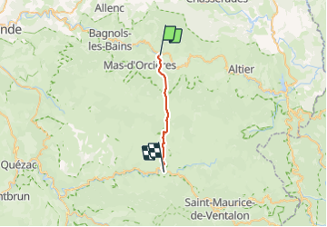

Length
17.7 km

Max alt
1636 m

Uphill gradient
621 m
Km-Effort
27 km

Min alt
882 m

Downhill gradient
805 m
Boucle
No
Creation date :
2023-09-17 06:06:29.549
Updated on :
2023-09-17 16:27:39.789
5h30
Difficulty : Difficult

FREE GPS app for hiking
 SityTrail
IGN / Geographical institutes
SityTrail Plus
The world is yours!
About
Trail Walking of 17.7 km to be discovered at Occitania, Lozère, Mont Lozère et Goulet. This trail is proposed by pjennes.
Description
de BLEYMART à LE PONT DE MONTVER
Positioning
Country:
France
Region :
Occitania
Department/Province :
Lozère
Municipality :
Mont Lozère et Goulet
Location:
Le Bleymard
Start:(Dec)
Start:(UTM)
558797 ; 4926599 (31T) N.
Comments